How the archaeology
got onto the map
Understanding how archaeology ended up on the map lets the map be read more intelligently. C. Fleet, correspondence, 2026
Five ways a find reached the sheet
Every antiquity on a Victorian Ordnance sheet arrived by some route — a surveyor's eye, a neighbour's word, a book on a shelf. The map's antiquity content is a mixture, not one testimony; each route carried its own kind of error, catalogued by F. J. Haverfield in 1906.
Direct field observation
A surveyor sees an extant earthwork and records it.
Named informants
A neighbour supplies the name; it is entered, with the informant, in the Object Name Book.
Printed sources
County histories, antiquarian maps (Hoare), society proceedings.
Special surveys
Dedicated Ordnance surveys of particular monuments.
The 1920 reform after the first edition
Crawford's Archaeology Division, aerial survey, systematic period review.
The lettering dated the find
The Survey lettered antiquities by period — the earliest in one blackletter hand, later ones in another, Roman remains in Egyptian capitals. Which face meant which period was fixed by the document in force when a sheet was engraved. That rule moved.
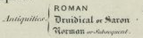

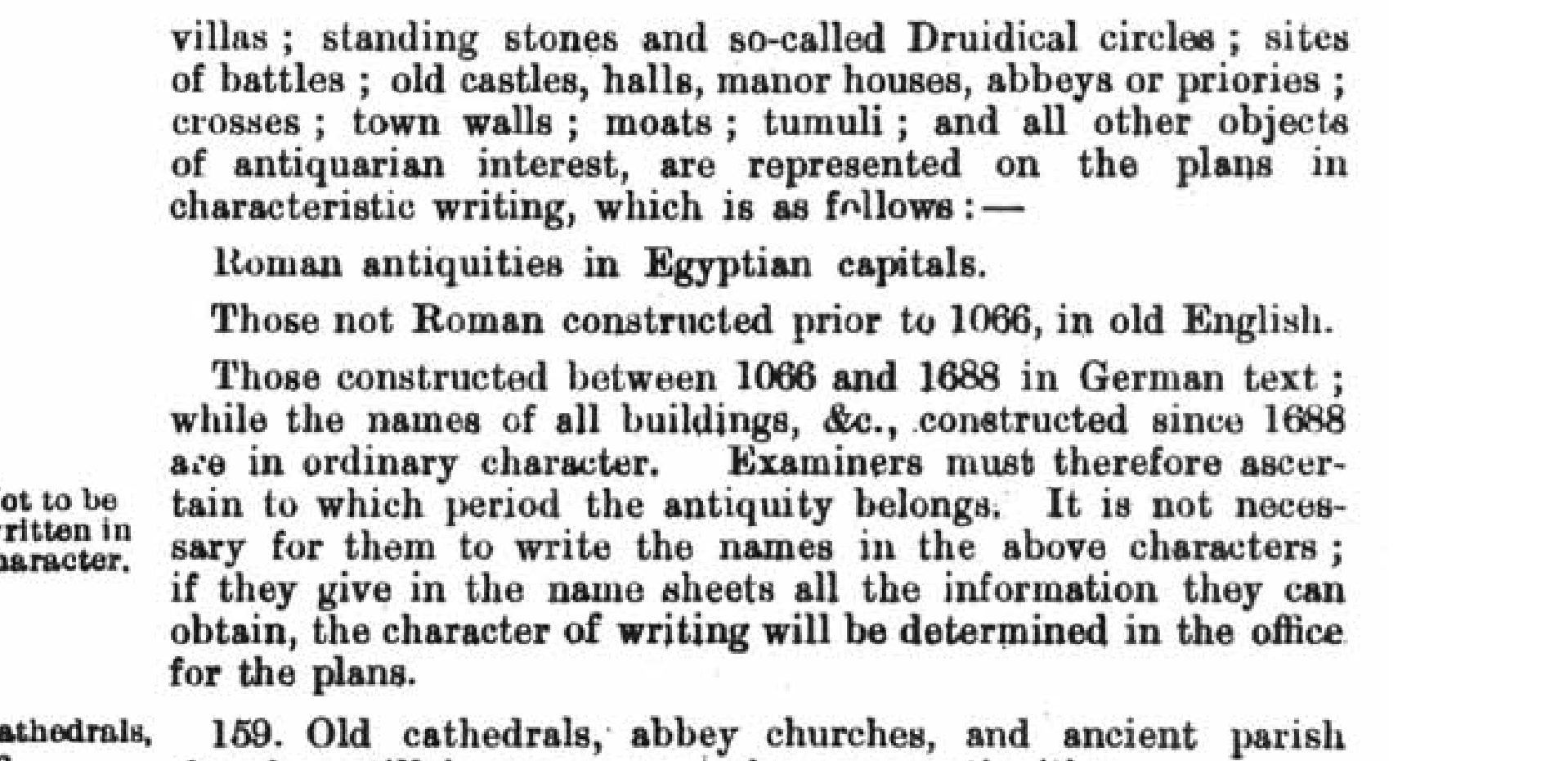

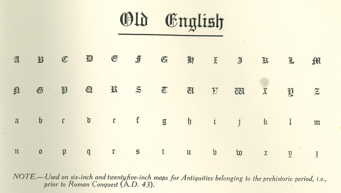
Settled. Phillips's paraphrase of the 1884 Instructions inverts the scheme the printed legends carry, and the primary now says so. The Instructions were revised and reissued in 1905, and that reissue survives: “Roman antiquities in Egyptian capitals. Those not Roman constructed prior to 1066, in old English. Those constructed between 1066 and 1688 in German text.” Old English spans everything before the Conquest; German text begins at it. Phillips reported the two blackletters the other way round — and his own footnote cites the 1905 reissue he was reading. The document was found by C. Fleet, who first suspected the paraphrase from the legends alone.
The sheets agree with the legends, not with Phillips: of 33 monuments of independently-known pre-Roman date on sheets surveyed after 1884, all 33 are lettered in Old English and none in German Text. Two post-Conquest monuments in the control set — a castle of c.1108 and a siege ringwork of 1139 — are lettered in Old English where the legend requires German Text. Those two are unexplained, and are being reported rather than tidied away. The toggle shows what is at stake: read a c.1888 sheet by the wrong instrument and every date inverts.
Cairnpapple Hill — who told the surveyor
For most Scottish names the Object Name Book records not just the name but its authority. Here is the whole chain for one antiquity, read end to end.
for spelling Revd J. Duns
Mr D. Thomson
Original: Object Name Book, OS1/34/55 — © Crown copyright, National Records of Scotland.
· Mr D. Thomson”
& Bronze Age cairn
The surveyors wrote down what they were told;
now we can read who told them.
One lineage — and the breaking of the circle
“[The National Archaeological Record] may be directly traced back to the card index and map system developed in the late 1940s by Ordnance Survey for the depiction of antiquities on the nation's maps.”
— Hart & Leech 1989, p.57
Shared ancestry, not independent witnesses. When a first-edition label “agrees” with a modern record, part of that agreement is inherited — the record grew from the map. Absence is not a clean signal either.
That is one lineage. It is not the only one.
C. Fleet (correspondence) makes the case that twentieth-century practice cut the inheritance repeatedly, and the record bears him out:
- Re-investigation. The Royal Commissions and, from 1920, the OS's own Archaeology Division questioned the earlier maps at the outset. Features were re-recorded, re-designated, or deliberately excluded at revision.
- Aerial survey. From the 1920s this added a very large number of features the ground survey had never seen — a route to the record that owes nothing to the earlier maps.
- The worked case. The Revd Duns's “Fort” on Cairnpapple Hill is no longer a fort. Excavation reclassified it as a henge and cairn: the map's own testimony, overturned by evidence the map did not supply.
And the correction can cut the other way. Beresford's work at Wharram Percy records Captain John Bayley, a keen antiquarian, accurately locating deserted medieval villages for the Yorkshire first edition — whose descriptions later revision made vaguer and less useful. Re-attribution is a signal, not automatically a correction.
So there are two hypotheses, and they are measurable. Either residual inheritance still inflates map–record agreement, or the circle was broken well enough that it does not. The stratified comparison this programme runs — agreement scored separately against records whose evidence is independent of the map — will report the gap, whichever way it falls.
What the notebooks actually say
Thirty-four antiquity entries were read across two counties' Object Name Books — West Lothian (Torphichen) and Orkney (Birsay, North Ronaldsay). Three results follow, none of them what the classification assumed.
Mr D. Thomson
New Statistical Account
Fullarton's Gazetteer
Forrest's County map
Entries were read from the transcribed volumes on ScotlandsPeople; no page images were taken, and one volume was read per parish. Of the twenty West Lothian map labels sampled, nine were too fragmentary to search — a measurement of the recognition pipeline rather than of the archive. The readings are machine-derived and have not been checked against the page images. Extending beyond this sounding requires a transcription-data agreement with National Records of Scotland.